Weather forecast for Wednesday December 6th, 2023, East Coast/VA USA:
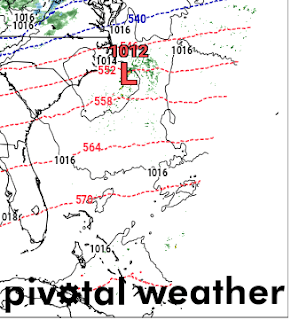
Rain is expected to impact the Virginia coastline area Tuesday night into Wednesday morning, and some spotty precipitation through the afternoon. A Coastal Low develops off the coast of Carolina early Tuesday, but due to a strong trough ejection in the jet stream, it is pushed offshore and just leaves some rain behind.
A surface low develops over the Chicago area Tuesday night, resulting in snow over the Lakes and into Ohio, Pennsylvania, West Virginia and the western Virginia mountains.
The NAMNST model is the most reliable to me, although everyone has their preferences. The GFS and EURO never seem to do well at picking up on accurate temperatures and any changes in the atmosphere during an active weather pattern. But the weather doesn't always do what the models pick up on.
The temperatures in the Virginia coastline region have been above average for November into December but expect them to drop off back to average Monday night into Tuesday and ongoing the remainder of the week.
This ridge in the West and trough pushing off the East may be the driving force behind the signal for a more significant weather pattern for the upcoming weekend, but we will take a look Thursday and every day thereafter to check for consistency within the models. Don't want to get ahead of ourselves.
Below are some images I captured utilizing pivotal weather 3kmNAM models, looking over the 700mb jet stream, 850mb temps and wind, as well as the surface temperature and precipitation products.
Be ready to bundle up as the temperatures drop and have your umbrellas! That'll be all for now, stay tuned for more updates, thanks for reading!
 |
| 700mb trough |
 |
| 850mb Wind and Temp |
 |
| Surface Temps |
 |
| Low being pushed offshore by trough |


No comments:
Post a Comment