Thursday, January 18, 2024

Wintry mixture for Friday Morning Jan 19th Hampton Roads

 Forecast for Friday Jan 19th Hampton Roads

  Hello again everyone!  This system moving through tomorrow may be the last chance for any wintry precipitation this month.  Expect some sleet/ice/rain mixed in tomorrow morning around 6am, be careful on that commute!

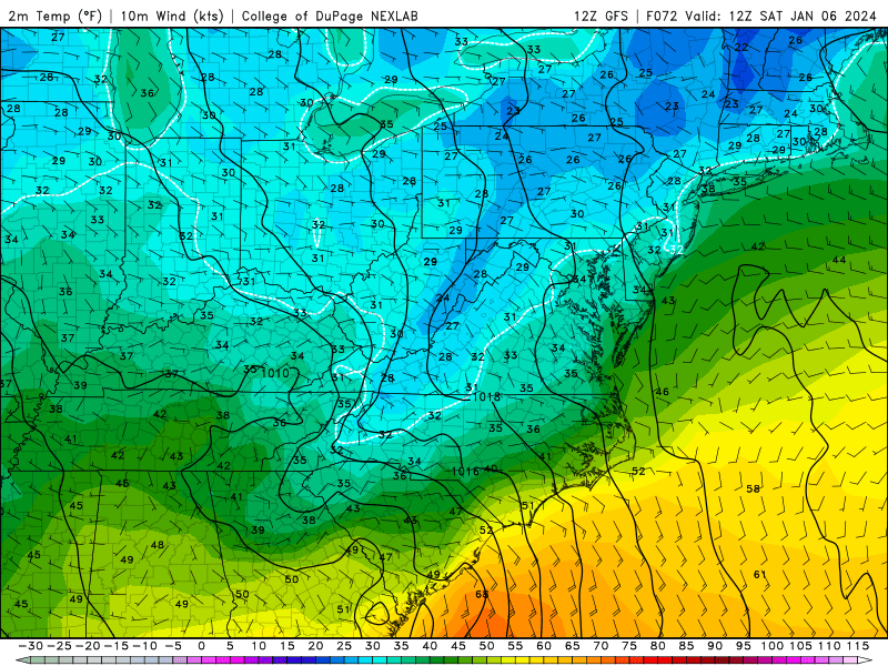
  The temperatures are struggling to remain freezing or below when the precipitation moves into the area.  The last couple days have been a real cold snap, but the storm systems that have been moving through are continuing to bring the warmer southern air and ocean temperatures with it, remaining too warm for any snow to accumulate.

  Although the temperatures aloft are very cold, as the Arctic air from up north circulates south with the El Nino pattern, the surface remains above freezing in the peninsula areas because the water surrounding it takes longer to cool off, leaving the temperatures too warm during the day to allow the ground to stay frozen for snow to accumulate.

  Next week the temperatures rise into way above average, highs in the 50s and 60s.  This is why most likely, the next chance for snow will be next month.  Still have a long way to go this winter!  If we have a later freeze then it may even last into March!

Stay tuned for more weather updates, stay dry and take it easy on the roads!

Thanks for reading.


Wednesday, January 10, 2024

More High Winds and Heavy Rain to impact Hampton Roads Friday Jan 12th

 Forecast update for incoming weather Friday!

  Hello again folks!  As mentioned before, El Nino climate pattern results in an active weather pattern, so again we have more rain and wind arriving Friday evening.

  It will begin raining around 8pm, although there could be some showers before that. It will continue through the night and into early Saturday morning (3am).  This system is similar to the one that just impacted the area, and if you lost power from that or had flooding, prepare for it to occur again.

  The ground is now super-saturated and cannot retain anymore water, so the potential for flooding especially at the coast is elevated.  The heavy downpours will be more widespread and the system will move quickly which is a positive.

  There will be more high wind gusts with this system, and still too warm for snow in this area.  Since these systems are being generated in the south, it pulls the warm, moist air with it to this region, so that's why the temperatures rise when they are in the area and it doesn't result in snow.

  There was a reported wind gust at a pier in the Outer Banks of 101mph with this last system that moved through, so it definitely had some serious wind associated with it.  The most severe weather right now is looking to remain South of this area according to the SPC 3 day outlook.  By tomorrow there will be a more defined picture of specific severe weather threats.

  Expect an active season, and eventually it will remain cold enough to produce some snow by the end of this month (looking long-range, high uncertainty).  The winter is young!  Speaking of cold, temps will dip to lows in the 20s by early next week, so bundle up!

  Stay tuned for more weather updates, and to see if my winter-weather prediction pans out!

Thanks for reading!


Sunday, January 7, 2024

Rain, High Winds and potential for severe weather in Hampton Roads Tuesday January 9th, 2024

 Forecast for Hampton Roads VA Tuesday January 9th

  Hello everyone!  With the El Nino climate pattern active, we can expect back-to-back storm systems impacting the area.  The one occurring Tuesday will be warm!  It's interesting to look at the steep temperature gradient when the system moves through, bringing temps to the 60s.  Way above average for the month of January.

  Keeping an eye on the severe weather potential for Tuesday night and the flooding risk with this system.  Since the ground is already moist, the steady rain and heavier amounts with this system can result in flash flooding.  Please remain prepared and alert for local warnings and watches.  If you know your area is prone to flooding, remain vigilant and don't drive through flooded or closed off roadways.

  The rain will begin Tuesday morning and the heaviest will arrive Tuesday night.  The NAM model shows potential for some clearing or a break in the steady rain in the afternoon.  In the summer, this is a common alert for forecasters, as this leaves room for the sun to heat up the surface and create more severe storms for later on in the day during peak heating hours (4-5pm).  The difference in the summer is the sun angle, so this time of year any clearing happening after 1pm before the more severe weather rolls through, shouldn't have a big impact.

  A part of the system being driven across the coast is the cold front behind it.  It pushes against the warm sector, which will spark the heavy rain and high winds.  Temperatures will go from the 30s Monday night, to the 60s in the afternoon Tuesday and fall back again to the 30s by Wednesday night.  Expect a possibility of power outages Tuesday night as the winds pick up, and flooding risk as the week progresses.  

I've included some animations from the weather models.  Thanks for reading!

Precip NAM Tuesday Jan 9th


Temp NAM Tuesday Jan 9th


Wind Gusts NAM Jan 9th


Friday, January 5, 2024

Update to Coastal Storm/Winter Storm Ember impacting Hampton Roads

 Forecast update for the weekend storm ahead

  Welcome back!  Excited to share an update on the incoming weather this weekend.  Noticed on the short range models that the wind gusts have some hefty characteristics, accompanied with the rain.  Yes, it is still remaining rain since it will be too warm for snow when the system moves through.

  Now that the timing is more aligned, it'll begin Saturday around 9am, spotty for most of the day with the heaviest rainfall later in the afternoon.  Wind gusts peak at about 42 mph around 5pm, but expect the wind to be wicked throughout the day.  Temperatures will be low to mid 50s when the system comes through, then dropping Saturday night back into the mid 30s.  Be on the look out for slick spots in case it freezes over the wet surface for Sunday.

  Below are some images captured from the NAM, which is pretty well aligned with the Euro and other American models.  The storm track may move a little slower or faster than the models predict, but always expect a margin of error with forecasting.

  Thanks for reading!  Stay tuned to local weather alerts and upcoming weather events!


Wednesday, January 3, 2024

Coastal Storm to impact Hampton Roads and western VA Saturday Jan 7th to Sunday Jan 8th

 Forecast update for Coastal Storm this weekend

   Hello everyone!  Wanted to post an update on the incoming Coastal storm Saturday January 7th into Sunday January 8th.  While tonight January 3rd, the Hampton Roads area can expect some rain, it should be cleared out by the morning commute, but remain cold.

  The active El Nino pattern has taken full swing, and with that we've got Surface Lows continuing to develop over the Gulf, and make their way over to the East Coast.  Although the temperatures remain average for now, when this storm is projected to be in the area it will still be too warm for snow.  The Western side of the storm will remain cold and drop some snow over the mountains.  The largest impact this system will have is forecast to be in the New England area.

  Since the system is arriving late Saturday night, the middle-range models show it best and both European and GFS models are agreeing more with what the storm is going to do.  While there is still some uncertainty and the storm could shift, right now looks like Hampton Roads will have rain and possibly high winds on the back side of it.

  I was excited to learn that GIFs and animated images could be shared from the weather models, so I will include those below.  Notice how the orange/yellow temperature color gradient dominates over the coast at the same time the precipitation is in the area.  This shows it will be warm enough for rain.

  Snow lovers don't lose faith!  We've got a long winter ahead and the climate patterns are still favorable for snow and consistent average to below average temperatures.  We will just have to wait it out to see if the Hampton Roads area is broken of its 3 year long snow drought!

  Stay tuned for more updates as the system approaches, be on guard for local weather alerts this weekend!

  Thanks for reading.


Tropical Storm Debby

 Potential for Tropical Storm Debby to impact Hampton Roads    The first potential tropical storm to impact our area is brewing off the Flor...