Potential for Tropical Storm Debby to impact Hampton Roads
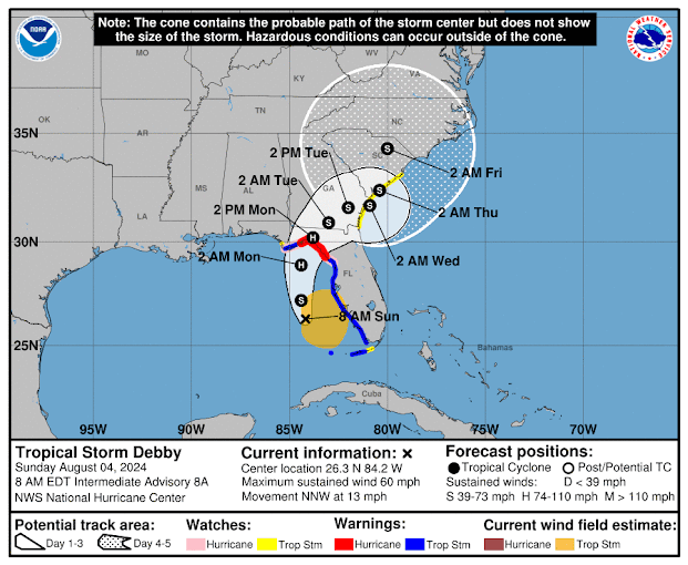
The first potential tropical storm to impact our area is brewing off the Florida coast. It is expected to develop into a Hurricane before landfall, however once it reaches land it will be likely downgraded to a tropical storm. The weather models are still in a bit of disagreement with how long it may linger at the Florida/Georgia border, however what we know now is that it will bring flooding rainfall.
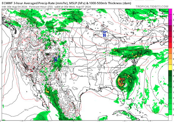
The risk associated with the Tropical Storm slowing down at the border will include storm surge as it makes landfall, and tropical rainfall amounts are astronomical when measured by weather models. The amount of moisture and the storm spinning over an area for a longer period of time results in rainfall amounts equal to the area's entire years' worth of rain. There will be strong winds as well, but the water and flooding potential will be the biggest threat.
As far as impacting the Hampton Roads area, it is still a bit early to tell exactly what Tropical Storm Debby will do, however I can at least give information off the knowledge we have now. Depending on how long it takes the storm to move up the coast, it may reach the North Carolina and Southeastern Virginia coastline by Friday into Saturday. Since this area has already had above normal precipitation accumulation this season, the biggest risk associated with any tropical system moving into the area is flooding.
The Hampton Roads area is at a marginal risk for excessive rainfall for the later part of the week, Wednesday/Thursday and into Friday. This may be elevated once Tropical Storm Debby moves up the coast. Even if the storm is remnants by the time it arrives, it will still drop tropical amounts of rain in the area.
To prepare now for tropical storms affecting the region, have a plan in place for the need to evacuate if necessary, inventory your emergency kits now, and prepare for power outages with high temperatures. Do not drive through flooded roadways or around barriers. Monitor your local weather forecasts these coming days, as the forecast could shift and alter plans if needed.
Below are latest images of weather models, Hurricane center imagery, ensemble means forecasts and resources.
I will continue to monitor the storm throughout the week and post an update if necessary. Thanks for reading!


No comments:
Post a Comment